Thursday, March 28, 2013

Conflicts between People

Out of boredom, I have joined some social groups. Just within less than half year, I saw a few conflicts occurring between members. It is not just a minor skirmish. Strong words were used in the ensuing conversation.

It is really sad that things turn out the ugly way. It all started with one member saying something and the other person responded explosively.

I remembered during the half year period that a fiend of friends in FB posted a remark on my timeline. My immediate reaction is a feeling of "is it any of your business to comment like that". If I had responded explosively, it would make my friend embarrassed that his friend offended me. I choose to just brush it off with a humorous self tease.

On another occasion, I was using a FB group to lamenting on some facilities that is not well designed for a certain activity and is resigned to it. Another member of the group posted a comment. The comment obliquely says that I am a pessimist. Again, it is a comment that would make me feel offended. I would not want to react negatively.

There was a recent reaction to the government to increase the population in the future by taking in more foreigners. One friend is so adamantly against it that he posted some remarks on FB in a group's posts on a totally different subject. Obviously, you will get explosive respond from others who are new citizens.

Revengeful comments/actions posted due to past unhappiness against a person is a very sad thing to do. It guarantees a strong response. Life is short, why remember past unhappiness and continues to present and future?

People usually get offended by comments made by others. They are offended because the comments seems to point directly at them. Those who posted comments does not know or does not care whether others will be offended by their comments. Those who responded strongly does not know that the comments may be just a brainless thoughts by individuals. This is the source of conflicts.

A Chinese idiom "退一步海阔天空,忍一时风平浪静" is a very good advice to follow. It is translated as "take a step back and you will see a wider world, endure a bit and there will be peace". Just let people have their say and don't react instantly. It does not contribute to anything good if you lash out on others' comment.


Wednesday, March 27, 2013

Bukit Timah - Wallace Trail

Bukit Timah trail and Wallace trail are two different trails. However, they are connected at one point. This walking trail that I did is to walk through both trails.

To start off, you will need to take a bus to the entrance point. Bus Services 67, 75, 170, 171, 173, 184, 852 are available at the Southaven II stop (ID 42119). After alighting, walk along the path towards the city. You will reach Hindhede Rd. Follow the PCN sign along the road and you will reach a carpark. The visitor center is just next to it.
You might want to visit the washer rooms first before starting the trail. The trail starts with a steep uphill slope. It will be all the way up hills. Stick to the metaled road till you come to a junction.

Take the right hand side of the road. At this point a black bird with nice tail swoop down very close to me to catch a butterfly in the air. Too bad I don't know the bird's technical name.

You can find a number of people walking backwards down hill here. I don't know the real reason for doing so.

The summit of Bukit Timah hill is just a hut and two telecommunications tower. Since I went on a week day, there isn't much people. I remembered long ago that it is packed full with people during week ends.


To get to Wallace Trail, you will need to turn off to the right a short distance from the summit.

The very first thing you see is a very steep steps. The steps are very high. It is some times more than two steps on a normal staircases.

Standard practice in a jungle trail is this


It can be seen along the path.

Make sure you turn right on the very next trail junction.

Turn left on the next junction and you will reach a man made structure that look like a storage tank. I really don't know why it was there.

Use the right side of the trail and you will reach the Wallace Trail. Unfortunately, Wallace trail is closed indefinitely till further notice.


Some unhappy trackers must have pushed over the sign board. It was lying on the floor. I have no choice but to take to the road where the Education center is. Look how worn out is the stone carving.


On the way, snapped two flower pictures.


Further down the road, there is actually a no-entry sign. However, my plan is to go onto Hill View PCN. Thus I turned right into the trail here

The PCN trail is pebbled metal road. Not so smooth but still better than the jungle trail. At some point the trail goes right into a road then turns back to the trail again. You can distinguish the trail easily by sign boards and two stones right at the exit and entrance besides the road.

At the end of the PCN is Upper Bukit Timah Road. There is a map showing the PCN.

You can take the same bus on Upper Bukit Timah Road back to your location from here at Standard Charted Bank (ID 43061).

You can download the trail here.

Thursday, March 21, 2013

Cycling Support Vehicle

Cycling with support vehicle is an ideal. There are many functionaries that can be provided by the vehicle. Support vehicles are especially useful on long distance tours. The following are some of the functionaries that I have observed over the years.

Setup.

1. Must be able to load about 5 bicycles including the riders.
2. Carry medical chest.
3. Warning signs at the rear to alert other vehicles that cyclist are ahead.
4. Clearly marked so that cyclist know it is a support vehicle.
5. Able to provide mechanical assistance to the cyclist (repairs).
6. Ideally should have a co-pilot so that the driver can concentrate on driving.
7. Carry the camping gears on long trips.
8. Food and drink are made available.
9. Communicating equipment should be made available.
10. Knows the route well.

Role

1. Must have hazard lights blinking all the time.
2. Where possible, stay at the rear of the cycling group.
3. Watch out for worn out cyclists and to advice them to stop.
4. Provide sweeper functionality.
5. Act as mobile watering and food point.


Friday, March 15, 2013

How to choose a bicycle

Singapore government has been promoting cycling by creating Park Connection Networks and dedicated cycling paths. Just recently they proposed to create another 200KM of cycling paths. If you are those attracted to jump on the band wagon, the first thing you need to do is to get a bike.

Now getting a bike is easy. Just go to your neighborhood bike shop and you can easily get a bike of your choice. However, you may regret it later when you find that it is not really suitable for your need. Bicycles has evolved tremendously. There are many types available for different uses. The following is not a professional guide. It is just a general note on choosing a bike.

Racer bike- By its name you will know that this is not for causal use. This is the type of bike that you use for speeding on road. Being aerodynamic in design, your body is usually bent forward and you normally have a device that held your shoe firmly on the paddle. This bike is not for novice cyclist. The standard wheel size is 26".

Hybrid bike - This bike is also normally used for speeding. However, its design is a mixture of mountain bike straight handle, simple peddle (can change) and rugged body (for more rugged terrain). The standard wheel size is also 26".

Mountain bike- For people who would like to go off road into jungle trails, this bike have wide wheel diameters and very rough tires to increase grip on the ground. It is not designed for speed although with proper combination of gears, and wheels you can still go at high speed. Wheel size will vary with bike size. This type of bike is common in your neighborhood bike shop. It is commonly used for commuting on road instead of going off road. The handle is straight and the body bent is less acute.

Touring bike - This type of bike is used for long distance tours. You can attach carrying bags to the bike for touring purpose. Usually you have to go to professional bike shop to get one.

BMX bike - For kids who would like to do stunts with bicycles. This is the type used. There are some parks specially designed for this type of bike. You can go up and down ramps and stairs with this kind of bike. It is not meant for speed.

Fixed gear bike - It is now a popular trend to go back to ancient times where you cannot change gear. This type of bike is best for urban commuting. The handle can be straight or racer style. The paddle is usually simple.

Foldable bike - another popular trend in Singapore. The bike can be folded and carried into trains and buses (only if you are the only one carrying a foldable in a bus). They are usually super light. Some could really speed while others are designed for casual cycling with modest speed. Don't be surprised that many of them have only one brake. The standard wheel size is 20". There are some with 18" or smaller wheels. You can really sit straight up with the handle raised high.

Carry me bike - Another specie of the foldables. This bike has really small wheels. Don't be fooled by the small wheels. It can also speed.

Professionals will tell you a lot more to the above simple description. However, for novice cyclists, just settle for the standard feature of each bike. You can "upgrade" later if you want.

As for the price, it has very wide range. Anything from sub $100 to $10,000. The quality of the bike will determine the price. It really depends on your budget.


Geotagging a photo in Picasa Web

When taking a picture, it will be good to have its location remembered. The term used for this location storage is called Geotagging. More and more cameras now come with geotagging feature. Naturally, Android and iOS both include it as a standard.

Obviously, some privacy advocates will never want to turn the feature on. But, if you are on a tour, it will be good to geotag your photo especially when the location is not a famous spot.

The problem is that some times we do forget that geotag featured is turned off. When we return and process the photo, we are unable to show to our readers the location of the picture. My previous blog did talk about how to manually insert the geotag. This blog will tell you an even easier way.

Picasa Web is a place where you can store your pictures on line. The pictures were stored in albums. When you open an album, you will see a small map that show a number of markers. When you view individual photo, the map will actually show the location where the picture is taken.

Obviously, if you have not previously geotag your picture, you can't see the location information.  There will be a "add location" link next to the picture. However, it is only useful if you know the location name of the place. For those unknown location name places, it is practically useless.

Now, if you are viewing the album, there is a link called "view map". If you are viewing the picture itself there is also a link called "view album map". Clicking either of the link will show you a map with picture icons inside the map. Obviously, if you have not geotag your pictures, there will be few or none available.

I am not sure if you can access to the map when none of your pictures have geotag. Usually, I have at least one picture with geotag as I usually remember half way through that I have not turned on geotagging.

If you can access to the map, there is a button at the top left hand corner called "Edit map".  Clicking it will show the same map plus all the pictures in the album shown on the left. If you picture already have geotag information, it will show with a marker on the bottom right hand corner on the picture.

You can drag and drop any picture on the left into the map and it will help you to geotag the picture. To be more accurate in the location, I would suggest you go to the highest resolution in the map.

When you have finished your editing. Make sure you click "Done" on the top left hand corner of the page. It will bring you back to "view album map" page. You can then see the picture icons in the map where you have edited it.

One important note about the size of the pictures you upload. If you did not join Google+ your free upload is 800px on the biggest side. If you join Google+ it will be 2048px. Google allows 15GB of storage space (as at 2013). If you upload your pictures at the original size, it will count towards the size otherwise it will be free. So if you limit the size of your picture, you can have virtually unlimited uploads.

Unfortunately, Picasa Web may be on the way out. Google now automatically redirects you to Google+ whenever you try to view the picture. According to bloggers, this is a sign that Picasa Web is on the way out. I will really miss this nice feature plus the map view if Picasa Web is made obsolete.


Tuesday, March 12, 2013

Is PCN really for cyclists?

1. Pillar right in the center of the cycling path as found in Woodlands.

2. Pillars blocking the path like a gate left barely space enough to cycle through.

3. Have you tried cycling on PCN after heavy rain?

4. PCN submerged in mud water at Punggol.

5. PCN becomes a stream with water flowing along it in Woodlands.

6. Super blind corners created by Rail pillars.

7. Super slippery PCN as found in Mandai PCN.

8. Cycling path widens and narrows on PCN between MRT rail pillars.

9. Have you ever see a PCN that is only a person's shoulder width as near Bukit Gombak MRT.

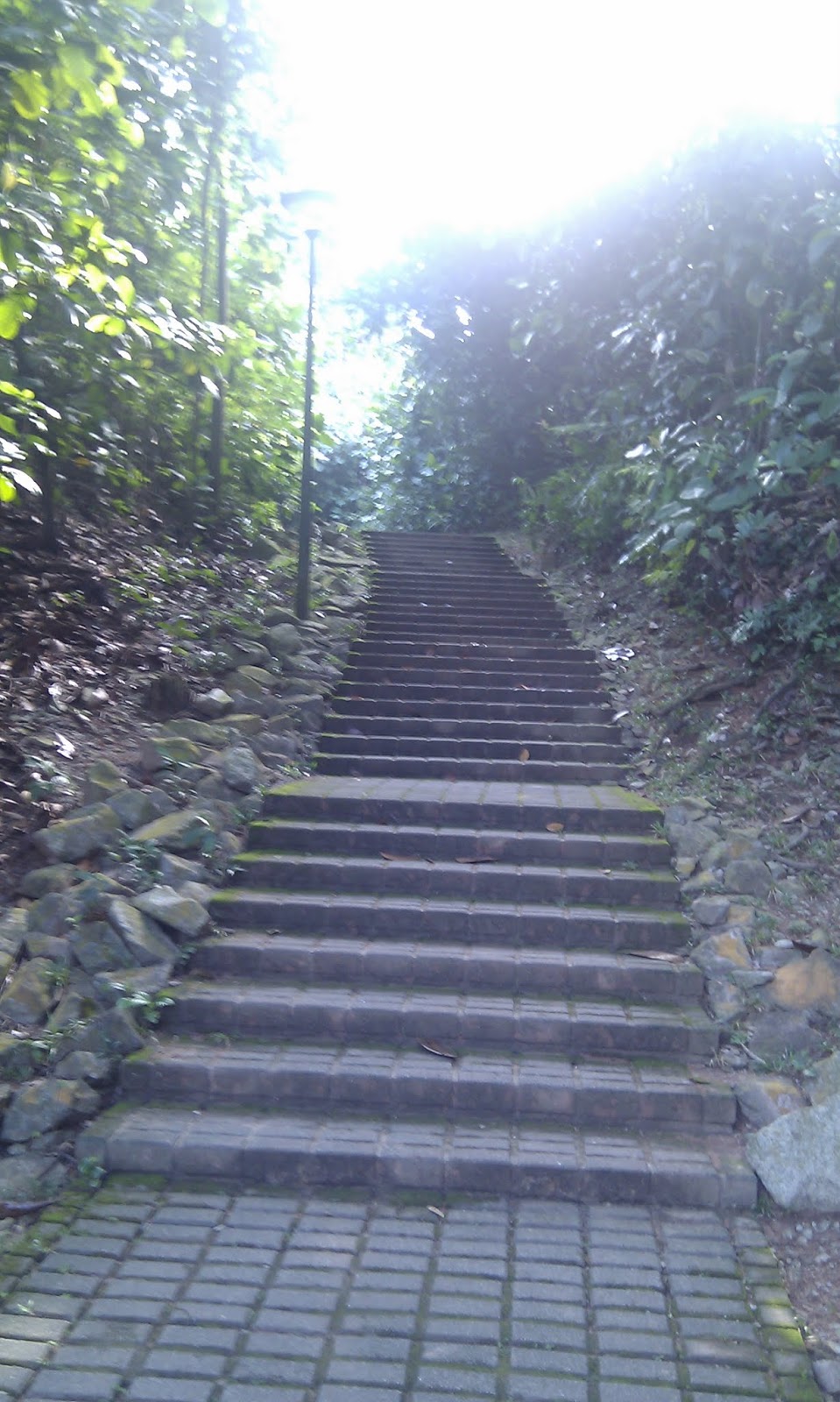
10. Have you tried to cycle down from Bishan to GBB via PCN? There are at least 5 places where you need to carry the bike over bridges and steps.

11. Have you tried to cross from Ulu Sembawang PC to Mandai PC. You will have to wait an extended time for the traffic light to change even though there is nobody crossing for the past hour before that.

12. Do you want to know how many road crossings From Khatib to Woodlands MRT? There is a sign asking you to dismount and push your bike across on major junctions.

13. Have you tried to cycle up the S turn near Woodlands Ave 7?

14. Have you tried to cross the Sembawang Rd via PCN? You will bite your tongue if you do.

15. Have you cycled on cycling path at Pasir Ris Dr 3 near Elias Rd? How does the snake path feels?

16. How safe is it to cross a road without pedestrian crossing mark or traffic light yet remains a PCN path?

17. Would you be surprised that some PCN are actually off road dirt trails?

18. How do you cycle without getting frustrated with groups of people walking on cycling path and ignores the walking path just besides it?

19. How does it feels cycling across drainage covers a few meters apart especially those that make noise when you go over it?

20. Have you ever missed the cycling track and end up on Pedestrian walk as there is no sign showing where is the cycling path.

21. Have you tried to cross Admiralty and Sembawang MRT via PCN? The pcn suddenly disappears without you knowing how to go across the MRT.

22. Have you tried to use the PCN between Republic Poly and Woodlands MRT around 6pm? Don't, else you have to get down and push your bike all the way. There are hundreds of students covering both Cycling and Foot path.

23. If you have gone cycling at East Coast Park. You would have experienced sharing the road with pedestrians, roller bladers, children, novice cyclist etc.

24. Perhaps you may not notice. The max cycling speed on PCN is 15Kph - just slightly faster than running.

25. Before you embark for a PCN trip. Check with NParks web site. It may be under repair. Chances is that you may not find a notice available on your specific route but it is there nevertheless.

26. NParks web page is a good place to find information. Just that you can't find a link that shows all the maintenance work in progress. Many times I tried to go on a particular PCN just to find it closed under repair.

27. It is great to find information on the PCN especially directional indicators. Just don't think that it is consistent. Many places will lead you nowhere. I used to go off the track on those.

28. Some parks are not significantly marked. For example Admiralty Park entrance near Woodlands Ave 9. No signs whatsoever. PCN is Park Connector Network right?

29. Some PCN routes are just across the road. However, there is no way to cross it. Typical example is Kallang PC and Kallang RiverSide PK.

30. Some PCN actually goes into a Carpark with no signs saying that it does. You are actually going on roads shared with vehicles.

31. One particular PCN is actually using part of a road as PCN. It won't tell you. The road pcn is Moonstone Ln.

32. Some rerouted NParks does not block the discarded route. You may end up in a dead end if you enters it. Typical one is found in Yishun.

33. Fancy going on a PCN then find that it is used for "pasar malam"? Usually the stores occupy the cycling path. How would you coup with cyclists, pedestrians, and shoppers on the remaining walking path?

34. If you are a vehicle driver, at a major plus (cross) junction with side turning roads, you only have to cross one road and be worried about the car opposite you turning. But as a cyclist crossing such junction, You have to cross three roads and two road islands plus having to scan 360 degrees for people, vehicles, bicycles and the ground condition. Luckily, you don't have to look up for flying objects.

35. If you are a pedestrian, turning 90 degrees is never a problem. But if you cycle, and try to turn 90 degrees at 15Kph into a one meter wide path. You must be an acrobat. If you fail to make it, you are certain to fall down the curb into a road.

36. Walking around corners with structures blocking the view is called turning at a blind corner. Cycling through a two way blind corner with a width of 1 meter is a sure invitation for shock. Assuming both sides going at 15Kph, You will meet each other at 30Kph or 8 meters per second.

37. How tight can you make a U turn on a bicycle? Some PCN has routes that is almost a U turn and a width less than one meter. Even an experienced cyclist find it tough to make the turn. Again it is a two way path.

38. Was told by a cyclist friend that his bike wheel go into drainage cover grills. Surely a wheel width that is no bigger than the thumb can be dangerous if the drainage cover grills are not places in the right way.

39. Before you embark for a PCN trip. Check with NParks web site. It may be under repair. Chances is that you may not find a notice available on your specific route but it is there nevertheless.

40. NParks web page is a good place to find information. Just that you can't find a link that shows all the maintenance work in progress. Many times I tried to go on a particular PCN just to find it closed under repair.

41. It is great to find information on the PCN especially directional indicators. Just don't think that it is consistent. Many places will lead you nowhere. I used to go off the track on those.

42. Extremely bumpy rumble strip at Khatib Bongsu PCN

43. Cyclist have to cycle down a small bumpy at Ang Mo Kio Avenue 6

44. Perhaps you may not notice. The max cycling speed on PCN is 15Kph - just slightly faster than running.

45. Ceramic tiles for blind near junctions are slippery when wet. It is dangerous for narrow slick tires especially when turning.

The above list is not all the issues that confronts cyclists. There are probably more. Some of the item are contributions by others.


A tale of two Bukit

This is a walking trail that commences from Bukit Batok MRT and ends at Bukit Gombak MRT. It covers two popular parks in the Bukit Batok Natural Reserve.

Since it starts and ends at a MRT, there is no need to mention about how to get there. However, the trail does not start at the formal entrance to the BBNP. There is a broad walk way right beside the sign below that leads directly to the query.

Our trail starts at the carpark to the left of the broad walk. Right inside the carpark is part of the PCN that curves along Bukit Batok East Ave 6.
There is a sign board that indicate the trail that I am walking into.
As indicated on the map, the trail will end at a broad walk which leads to a compound with a hut.
Along the broad walk you an actually see a spring where water oozes up from the ground.

Since there is nothing special about going around the hut, I choose to bypass the hut instead. At the end of the path, there is a confusing junction with another signboard that is slightly further down. Turn into the right hand path instead. From here on it is all up hills.

At the end of the trail you can see a carpark. The transmission tower is on the right hand side.

Turning back into the trail, I came back to the same junction again. This time I take the left hand trail. This trail leads to the first query.

Unfortunately, I am supposed to take a set of overlapping shots to make a panoramic picture. The WikiLoc picture taking has a bug. If I take a picture then click on the camera icon to take another one instead of exiting, only the very last one is saved. Very unfortunate. The same thing happens at the next query also.

Walking out on the broad walk, There is a toilet and a children's playground plus the usual exercise gadgets.

Instead of walking right out on the broad walk, I choose to enter the trail again. the trail leads me back to the carpark.

There is a PCN that leads all the way to the Little QuiLin. All the shots were lost as mentioned earlier. The following is some that remains. The picture quality is bad because the sun is towards the camera. Should have gone there in the afternoon instead.

I did not explore inside the park. Following the PCN, I end up with Bukit Batok MRT. The total distance is about 6.5KM. However, my Endomondo Sports tracker shows almost 9KM.

http://www.wikiloc.com/wikiloc/view.do?id=4108204

Wednesday, March 06, 2013

Sungei Buloh Wetland

A very nice place to study nature. You can access from bus service 925# during weekends and holidays. On weekdays you will have to take service 925 and drop at Kranji Reservoir Pk B (bus stop ID 499199) then walk in from Kranji Way to Neo Tiew Cres. Alternatively, you could take the Kranji Nature Trail. However, it is currently under re-construction. It will be ready after Sept 2013.

At this moment, Google map shows a road towards a round about at the entrance. OpenStreetMap shows the road leading to a carpark. The latter is more up to date. Look for a wooden trail to the left of the carpark. You will still reach the round about (no longer accessible by car). On the trail, you can see posters posing questions with answers below.

Along the way you can see a wooden mail box.
The visitor center is the point where the BroadWalk and the main reserve splits. Suggestion is to go to the BroadWalk first. Take the path to the right where you will enter a display area showing some of the stuffed birds. The entrance to the BroadWalk looks like this.

Once you enter the BroadWalk you will start to smell the mangrove swam air. It is a bit hard to take at the start but you will get used to it.

It was quite early when I reached the place. It was quite deserted. The only other person who is not working there is taking professional photos of a king fisher.
Along the trail you will see small labels that looks like this.
and
They are actually QRCode and ColorCode that you can scan and download information from handphone. Wireless@SG is also available if you do not have a data plan. I did not try it though.

You will return to the same entrance at the Guest Center. This time turn right to the main reserve area. The entrance looks like this.
Very interestingly at the shed on the entrance there is a warning hanging near the roof.
The actual trail along the way looks like this.
Along the way you will find quite a number of panels that look like this
These are spots where you could observe the birds and creatures without disturbing them. There are even houses built for you to enter and observe through openings. I was able to watch a large flock of birds from one of these.
Unfortunately, I have only my camera on my handphone to take pictures. You actually need a zoom camera of at least 400mm to take pictures from afar.

Some where at the middle of the track you will find a tower.

You can climb on top and view over the canopy.
Following Route 2, you will come across a few hidden views which is quite a distance off the trail. As you progress further. The land trail ends. You will need to go onto the bridge trail at this point
At the end of the bridge, you will venture back to Route 1. It is here that I saw an iguana about a meter long
Upon re-entering the Guest Center, I went to the Cafeteria. There is a pond with water lilies growing in it.
If you look at the right top corner of the picture, you can see another iguana sun bathing. There are some interesting plants in the pond also.
With that, I end the trip.

Just for curiosity, I took a picture of a scarecrow in front of a company's entrance some where near the entrance of the reserve. I don't know why that company put the figure there for.
I took two parnoramic pictures during the trip.
The first one is not so successful. The second look like fisheye picture. Both are failures.

If you are interested to visit the place, I have a map showing the route at http://sg.mapometer.com/walking/route_2794313.html. You could travel by bus or drive to the carpark and take the shorter way.