Wednesday, May 29, 2013

Botanic Garden

It was more than a decade since I last visited the garden. There are a lot of changes in the garden. The very first thing is that there is a MRT right at the gate.
As there were many themes in the garden and many more paths available too. The route I plotted only goes through some of them.

The path starts at the Eco Lake after entering the gate. The down town line is still under construction just outside the perimeter. Jacob Ballas Children's Garden is just at the corner but did not enter it. Instead follow the path to the fruit tree.
After that turns towards Red Brick Path. It is a up hill path.
You can see the slope here.
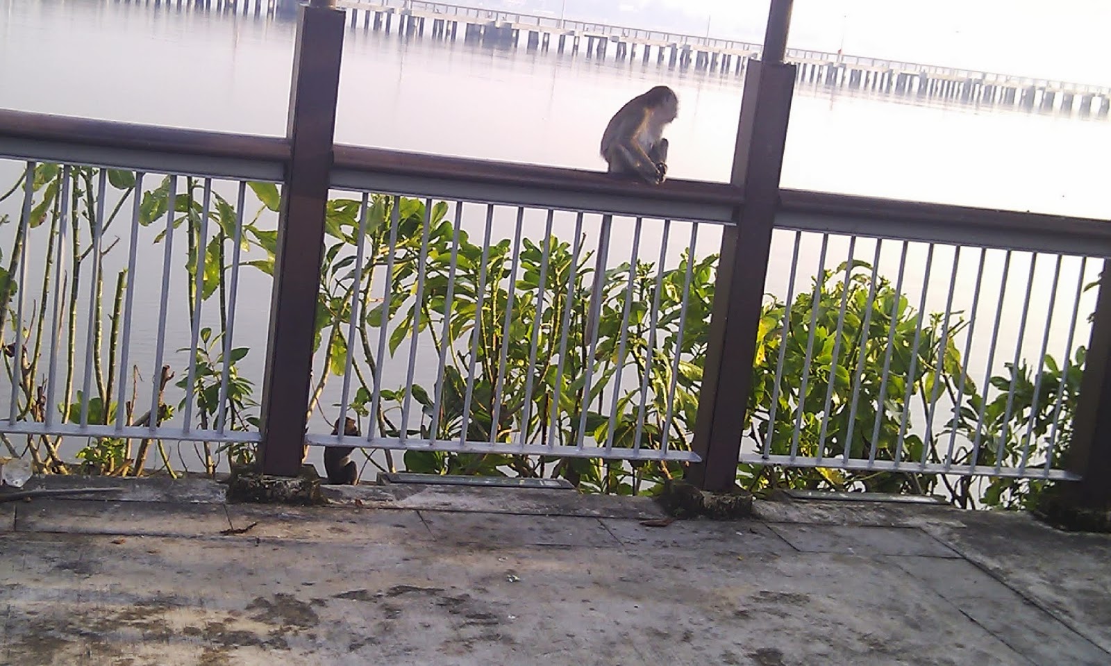
You probably don't know who is Jane Goodall (hint Chimpanzee). There is a institute in her name.
Fragrance garden is next.
Healing garden is just further down the path.
Passed by Nparks Headquarters on the way to Symphony Lake.
Symphony Lake have a pavilion for public entertainment.
Ginger garden are full of plants of the same species.
The Orchid garden is just besides it. Since it is a paid entry, the path does not include it.
Walking between the two signs you enter the Ginger Garden. There were man made waterfalls in it.

You can actually walk right under it. After ginger garden you will reach Sun Garden. It is actually desert plants. It is quite a small place. Sundial garden is just next to it. Unfortunately, the sundial does not look like one to me. It is situated in the center of a lily pond.
The swan lake is just further down the path.
In the middle of the lake there is a large sculpture.
There were many fishes in the lake. The lake sure look murky.
Further down, there is a sculpture in the middle of a bush. I guess it is called "Mother and Daughter".
Furtherdown, you can walk off road into the "Swamp" or Marsh Garden. Obviously, you don't expect to walk right in the swamp don't you? There is a foot path.
After the swamp the road leads to the main gate. I choose to turn off the main gate road into a wining path around a stream. There are footsteps available if you choose not to walk on the wining path.
You probably want to stop for a short while listening to the running water. It is really refreshing. Met many children on their educational trip with teachers.
On the way, saw a stone ball turning on water in the middle of the road.
Spotted a sculpture that depicts a girl watering plant and another girl sitting on the floor watching her. Some humorous person put a real plant in the hand of the sitting girl. By the way, the plant is real.
On the way, passed a path with plant's root flowing around it. Very nicely done.
At a junction, found a sculpture on a swing. You would miss it if you don't look in the direction.
As a cyclist, I just can't miss the small sculpture of a girl on bicycle.
Further down, there is a long wooden bridged path through the Rain Forest.

After the path, passed the Symphony lake again to reach the Evolution Garden. Made a few wrong turns just because the path actually need to go round the garden and pass under each other. Surely, you won't know it unless you are there.  Took a few pictures.
There are a number of sign boards telling you about the evolution.
Since it is a botanic garden, you don't see animals in the garden. Sorry T-rex is never a theme. It is just plant evolution.

By now my wikiLoc app keep crashing out. Luckily, it can continue the path even after exit. But there is no way to add waypoint or even take pictures. The rest of the pictures are taken  without using the app. Luckily, it is almost the end of my plotted path already.

Took a few flower pictures. You can see all the pictures in my picasa web album. https://picasaweb.google.com/106611639464075912591/BotanicGarden

If you want to know exactly where the pictures are taken, use the map facility in the album. However, the path information is not there.

WikiLoc path is still usable except that it did not really recorded right to the end. However, it is still very near to the end. Waypoints are not available most of the way on the return trip.

http://www.wikiloc.com/wikiloc/view.do?id=4571874

I realize that GPS has a hard time reading the location under heavy tree canopy. I keep having the location fix too slow to show me exactly where am I. Thus, there are quite a number of time I end up not following the path and had to turn back to find it.

I have converted the Endomondo GPX of the same route into KML and exported the Picasa web to Google Earth. The next thing to do is to create a Google Map by importing both KML. Here is the link.

https://www.google.com/maps/ms?msid=202562666809434630264.0004ddf7700b67ffe0515&msa=0&ll=1.319053,103.815705&spn=0.001317,0.002159


Sunday, May 26, 2013

Cycling in NTU

It is a cycling trip organized by LCSG. The trip started from the Old Nanyang University gate in Yunan Garden. It is now just a gate. Surprisingly there is a replica in front of the Chinese Heritage Center.
The next stop is at the Chinese Heritage Center. It is free admission.
The next stop is the hanging bridge. According to the leader, it was closed to traffic since the 911 incident.
Passing the bridge, we came to the Army Museum.
The trip has a number of u turns and hill climbs. You can see from the WikiLoc link below.

After the museum, we wanted to go to NTU canteen 2 but was stopped by security from proceeding. Well, there must be a good reason for him to stop us from going up there.

We settled at another canteen near Students Walk. After having a quick bite, we went to the Community Herb Garden. There were quite a number of herbs grown there.
Since I know nothing about herbs, took a few flower pictures instead.
The trip stops at Dragon Kiln Village (Thow Kwong Industry, part of Kranji Heritage Trail). A number of them took a free guided tour from the owner.
I noticed a big pot that has plants growing over the water.
There is a lily pond with a white statue in it.
Out of boredom while waiting, took a few flower pictures here.

We dismiss from here. Most of them go back via Pioneer MRT as they were on Foldies. A few of us had to cycle back home as we are on non foldies.

http://www.wikiloc.com/wikiloc/view.do?id=4547740


Friday, May 24, 2013

New Google Map


Just got approval to access the new Google Map interface. It was a white washed map. Most of the features are gone. Just left the map/satellite view, location search and direction. Even the Street View is gone.

I was eager to try the cycling direction. Unfortunately, it is not available for Singapore yet.

I must admit that the 3D building view is a bit difficult to see. I still prefer the old 2D view.

There is a new feature. "Explore" shows you some pictures of the area and when you point to it, the location is shown in the map. For tourists, it may be good. For locals, it may not be so useful. Luckily it is default minimized.

The "traffic" feature is nice. It must be a real time indicator otherwise it is useless. Not sure how the refresh is done.

The "transit" feature is not much of a use. It is just a MRT map overlaid onto the background and highlighted.

The "direction" feature is a refreshing one. It showed all the routes available on the map. You could set it to "avoid toll" and "avoid highway". I just tried one from East Johor Bahru (Masai) to Bukit Panjang. Well, the route actually suggest I go all the way west to Second link instead of the much shorter Causeway link. Maybe the traffic condition is taken into consideration. Walking and cycling direction is still not available yet (in SG I guess).

The new map interface has become my default maps view. There is an option to go back to the classic view (the old Google map).

I now realize that Map Engine Lite and the new map are splinters of the old one. The former is re-engineered to make route plotting much easier (and less flexible) to use. Only Geeks like me would want to use the former while most people only uses the latter.


Wednesday, May 22, 2013

Woodlands Water Front Loop

I have traveled a few areas in Singapore. Woodlands Water Front Loop is one that I do not favor. You will know the reason after reading through the post.

The loop starts right next to Republic Poly. The entrance is on the right of the picture.
This is a relative small, narrow and short park. A few areas are currently closed for repairs. Took a few pictures of plants and flowers along the way.
Sakura Buffet Restaurant is actually situated in the park but the entrance is on Riverside Rd.
The path seems to end behind the restaurant. You need to walk around the structure below to continue on the path.


The north entrance to the park is actually a car park.
After the car park, Admiralty West PC leads you right to the Water Front. The sad part is that you have to cross the road at two points. The two points are perfectly normal. One have traffic light and the other is a zebra crossing. However, the motorcyclists coming in from Malaysia are not that friendly. Perhaps due to their rush to get to work, they ignore the traffic rules. I find them moving towards me despite I am already on the crossing. Some even speed pass right in front of me.

Please be aware that there are monkeys in the park. If you are careless, you might be chasing your belongings after them.
The water front pier is just in the back ground of the picture above. A close look is as below.
There is a eatery at the turning point. The last time I passed by at around 9am, it was still closed.

You can catch a view of our neighbor country here.

At this point, there is another crossing where you cross path with motorcyclists rushing to work.
Before you cross the road, turn back a bit and you will notice a cement book telling you about the history. Sorry, you can't turn the pages.
You will be on Marsiling PC once you cross the road.
It is a narrow up hill path. Near the road crossing point, the path is less than a meter wide. If you cycle, please be careful.
The PC leads you right to Woodlands Centre Rd. You need to take the spiral slope or the stair case to reach the road. The picture show the over head crossing at level point.
Walking along the road you will come across a junction where you need to do a "L" crossing. It is not a pleasant crossing as there are three pedestrian crossing where you need to press a button in order to cross. The amount of waiting for the light is frustrating. However, I can't blame LTA. This road is a very busy road.

Actually one elderly person on bicycle was trying to cross at the junction between Admiralty Rd and Woodlands Central Rd while the Red Man Light is on. He stopped near the road island then quickly cross it as the traffic is super heavy in the morning rush hour. I guess he is also in the rush too.

Woodlands Gardens is on the right hand side once you cross the "L" crossing. As the PCN does not go into the park, I just pass it by.
Further down the PC, you need to cross the road and turn right.
You will be taking Woodlands St 13 PC. To the right is Woodlands East Park and to the left is the Woodlands Sports Complex. In between you need to cross the road to walk on the other side.

Please be real careful when crossing Woodlands St 11. There is no pedestrian crossing on the 4 lane road.

The sign board above is huge. However, there is not a single entrance to the park near here. Odd.

At the end of Woodlands St 13 PC, you will cross the Woodlands St 13 to the Woodlands Ave 5 PC. Again there is no pedestrian crossing here. Walk carefully.

Woodlands Ave 5 PC and Woodlands Ave 2 PC together make a half crescent around Causeway Point. There is only one park near Woodlands Ave 5 PC (N Hood PK). The loop ends at the end of Woodlands Ave 2 PC. One stretch of Woodlands Ave 2 PC is worthy mention. At around 5PM, Republic Poly students will swarm all over the PC. It is almost impossible to cycle on the PC especially if you are going along their direction towards Causeway Point. They will certainly not aware of your presence even when you ring your bell.

By now you would have noticed a few mentions about unpleasant encounters while cruising on the route. That is the reason why I would not rate the route as good. As a Woodland people, It is sad to have such nice route that gives an unpleasant taste after the walk.

More pictures are available here. https://picasaweb.google.com/106611639464075912591/WoodlandsWaterFrontLoop

MapOmeter route information is here http://sg.mapometer.com/walking/route_2851854.html