The first disappointment when I came out of Tanjong Pagar MRT exit A is that the whole area is now walled up for construction. I expected a open field garden right between Exit A and Exit B. I had to turn a big round on the wrong side (north) to get to Exit B as planned.
Crossing the Maxwell Rd, I came to Telok Ayer park. It is green but not much flower except this Dwarf Tibouchina.
Going along Telok Ayer St, this Bird's Nest Fern grows in front of the Amoy St Food center. It is interesting that it is not just one plant. The whole section of the road has it.
It is not often I take picture of buildings. However, part of this route is designated by NParks as a walking trail. Some buildings are listed. I though I might as well include them as well. In actual fact, I missed all the trees mentioned in the trail as there were no sign boards indicating them and I have a hard time recognizing the trees. As I am not touring, I just passed by all the buildings I took picture of without going into them.
The first structure is this Thiam Hock Keng Temple. According to NParks, it is the oldest temple in Singapore.
The next one near by is Nagore Durgha Shrine. It is a meeting place for Indian Muslims. I missed the Al-abrar Mosque mentioned in the trail as it is not in my route plan.
The Telok Ayer Green Park is just beside it. This Habana cigar plant, a ginger, attracted my attention.
There are two bronze sculptures in the park. This one is "Chinese procession".
The other one is "Indian Settlers in Telok Ayer".
This plant could be Galangal Ginger. I am not very sure.
This is a Sacred Lotus. Its leaf is almost round. It is supposed to grow in water.
Found this Ruellia behind a shed in Ann Siang Park.
Made a wrong turn after going up a spiral staircase and saw this Chinese Honeysuckl
When I end up in Ann Siang Rd, I realize I am out of my plotted track. Walked back and forth around the place till I realize that the path is on the right of the spiral staircase. Well, at least I found out who is Ann Siang. This sign board is near Ann Siang Rd. Took the picture with my L27 thus no GPS info.
Found this Panama Rose that looks like the common Ixora from far. Almost missed this till I get a closer look.
This brightly colored Flabellata (a Heliconia) grows in abundance but only a few that have flower.
I love looking at this huge Hibiscus. It is as big as my palm (10 cm). Usually they are much smaller than this.
This nice variegated Bougainvillea 'vanilla ice' grows just outside the Ann Siang Hill Park.'
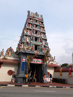
The route now turns into South Bridge Rd then Pagoda St. You can't miss the Sri Mariamma Temple. It is a land mark.
There were a lot of pigeons at Pagoda street.
Another view of the temple at Pagoda Street.
I have never realized that there is a bronze sculpture of a Samsui Woman with her distinct 'red bandana' ((红头巾). Actually most bronze sculptures does not have color. This one seems to be special.
1 Park Rd is still a road? It is so short and void of cars but it is still there with a big sign board.
The original plan is to end the route here. It was changed the night before going on this trip. The route continues to Upper Cross St and then Pearl hill's Rd before entering Pearl Hill Park.
This end of the park is green but not much plants to take pictures with. The trees are already too tall. The planned route was to take the longer path but decided to cut short and take the direct path instead.
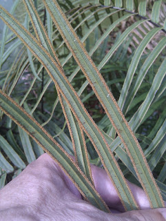
On the other side of the Pearl Hill Reservoir, there are a lot of Ferns growing in the park. As ferns are only interesting if you look at the back of the leaf. Therefore, I took the unusual move to turn the leaf back to take the picture. My normal practice is ESNT (eye-see-no-touch). Here are some pictures. The middle picture is Brake fern, the rest are Sword ferns.
In between the three pictures, I noticed that the footpath has tiny plants growing between the bricks. They really made a pattern on the path. It is a Purslande or something like that.
Over here, my GPS seems to be not responding well. I walked to and fro a few times to find my way around. Finally, took the wrong path and missed the long stairway down the hill according to OpenStreetMap. The stairways is not indicated in Google map or Streetdirectory.
I am glad I took the wrong path. There were two nice flowering plants on the path. The first one is the same as the one I found in Upper Seletar Reservoir. It is the Glory Lily. My last enlarged picture of this plant missed the stamens. This time I make sure the complete flower is in the picture.
The other plant is Hairy Clidemia.
Walking along the Pearl Hill Terrace, the route crossed South Bridge Rd again into Duxton Plain Park. According to internet this park was originally a railway track.
On entering the park, again there are a lot of pigeons.
Here also you will see lots of Habana cigar plant. They looked a lot nicer here.
There is a large field of Wild Pepper growing here also.
For the rest of the park, there isn't much interesting plants to take picture till near the end of it at Yang Kit Rd where there are Apostle plant growing. The close up picture is quite blurred as the flower is small and quite a distance from the leaves. I choose to show this one instead.
There is a Vanda Miss Joaquim Park just across Yang Kit Rd. It has a structure with a Chinese name on it. It is called 金兰园. According to internet this park is dedicated to the national orchid flower. Unfortunately, I did not know before hand thus does not look specifically for the orchid.
What I did find is this green bamboo tree.
Today is not a good day for GPS navigation. I got lost again at Gopeng St. Well, I found this Happiness tree while I am lost. It seems to be my lucky day to find interesting plants while lost.
Finally got the GPS correct and saw this Seng Wong Beo Temple. One of the landmark in this area. Actually "Beo" is already "temple" in Hokkein. The English banner in the picture is actually wrong.
After passing the temple, the route ends back at Tanjong Pagar MRT. Saw the area next to the temple being turned into an office building. There goes another green spot. I got lost because of this. The route is supposed to cut across it.
The WikiLoc route map is here.
The full Picasa album is here.


No comments:
Post a Comment