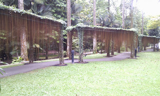
It was more than a decade since I last visited the garden. There are a lot of changes in the garden. The very first thing is that there is a MRT right at the gate.
As there were many themes in the garden and many more paths available too. The route I plotted only goes through some of them.
The path starts at the Eco Lake after entering the gate. The down town line is still under construction just outside the perimeter. Jacob Ballas Children's Garden is just at the corner but did not enter it. Instead follow the path to the fruit tree.
After that turns towards Red Brick Path. It is a up hill path.
You can see the slope here.
You probably don't know who is Jane Goodall (hint Chimpanzee). There is a institute in her name.
Fragrance garden is next.
Healing garden is just further down the path.
Passed by Nparks Headquarters on the way to Symphony Lake.
Symphony Lake have a pavilion for public entertainment.
Ginger garden are full of plants of the same species.
The Orchid garden is just besides it. Since it is a paid entry, the path does not include it.
Walking between the two signs you enter the Ginger Garden. There were man made waterfalls in it.
You can actually walk right under it. After ginger garden you will reach Sun Garden. It is actually desert plants. It is quite a small place. Sundial garden is just next to it. Unfortunately, the sundial does not look like one to me. It is situated in the center of a lily pond.
The swan lake is just further down the path.
In the middle of the lake there is a large sculpture.
There were many fishes in the lake. The lake sure look murky.
Further down, there is a sculpture in the middle of a bush. I guess it is called "Mother and Daughter".
Furtherdown, you can walk off road into the "Swamp" or Marsh Garden. Obviously, you don't expect to walk right in the swamp don't you? There is a foot path.
After the swamp the road leads to the main gate. I choose to turn off the main gate road into a wining path around a stream. There are footsteps available if you choose not to walk on the wining path.
You probably want to stop for a short while listening to the running water. It is really refreshing. Met many children on their educational trip with teachers.
On the way, saw a stone ball turning on water in the middle of the road.
Spotted a sculpture that depicts a girl watering plant and another girl sitting on the floor watching her. Some humorous person put a real plant in the hand of the sitting girl. By the way, the plant is real.
On the way, passed a path with plant's root flowing around it. Very nicely done.
At a junction, found a sculpture on a swing. You would miss it if you don't look in the direction.
As a cyclist, I just can't miss the small sculpture of a girl on bicycle.
Further down, there is a long wooden bridged path through the Rain Forest.
After the path, passed the Symphony lake again to reach the Evolution Garden. Made a few wrong turns just because the path actually need to go round the garden and pass under each other. Surely, you won't know it unless you are there. Took a few pictures.
There are a number of sign boards telling you about the evolution.
Since it is a botanic garden, you don't see animals in the garden. Sorry T-rex is never a theme. It is just plant evolution.
By now my wikiLoc app keep crashing out. Luckily, it can continue the path even after exit. But there is no way to add waypoint or even take pictures. The rest of the pictures are taken without using the app. Luckily, it is almost the end of my plotted path already.
Took a few flower pictures. You can see all the pictures in my picasa web album. https://picasaweb.google.com/106611639464075912591/BotanicGarden
If you want to know exactly where the pictures are taken, use the map facility in the album. However, the path information is not there.
WikiLoc path is still usable except that it did not really recorded right to the end. However, it is still very near to the end. Waypoints are not available most of the way on the return trip.
http://www.wikiloc.com/wikiloc/view.do?id=4571874
I realize that GPS has a hard time reading the location under heavy tree canopy. I keep having the location fix too slow to show me exactly where am I. Thus, there are quite a number of time I end up not following the path and had to turn back to find it.
I have converted the Endomondo GPX of the same route into KML and exported the Picasa web to Google Earth. The next thing to do is to create a Google Map by importing both KML. Here is the link.
https://www.google.com/maps/ms?msid=202562666809434630264.0004ddf7700b67ffe0515&msa=0&ll=1.319053,103.815705&spn=0.001317,0.002159


No comments:
Post a Comment